
Tool and Calculators
Useful Tools

Moovit
Moovit is a mobility as a service provider and journey planner app. The company uses both crowdsourced and official public transit data to provide route planning to users as well as transit data APIs to transit companies, cities, and transit agencies. Because Moovit integrates crowdsourced data, it is able to provide transit information for areas where no data is officially available.
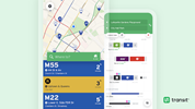
Transit
Transit is a mobile app providing real-time public transit data. The app functions in over 175 metropolitan areas around the world. Transit was designed for aggregating and mapping real-time public transit data, crowdsourcing user data to determine the true location of buses and trains.

Streetmix
Streetmix is an online tool to design, remix, and share your street. Add bike paths, widen sidewalks or traffic lanes, learn how all of this can impact your community.
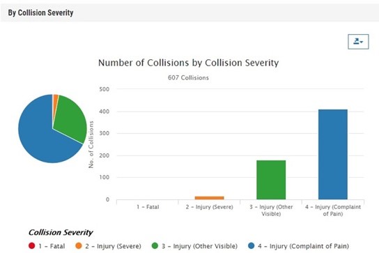
Transportation Injury Mapping System
The Transportation Injury Mapping System (TIMS) has been developed over the past five-plus years by SafeTREC to provide quick, easy and free access to California crash data, the Statewide Integrated Traffic Records System (SWITRS), that has been geo-coded by SafeTREC to make it easy to map out crashes.
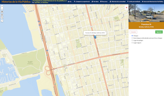
Street Story
Street Story is a community engagement tool that allows residents, community groups and agencies to collect information about transportation collisions, near-misses, general hazards and safe locations to travel. To promote access to the tool, SafeTREC conducts technical assistance with communities and organizations on using Street Story. Street Story is free to use and publicly accessible.
GIS Data Resources
- https://transitfeeds.com/news/open-mobility-data
- https://www.transitwiki.org/TransitWiki/index.php/Publicly-accessible_public_transportation_data
- https://transitapp.com/APTA
- https://transitapp.com/coronavirus
- https://moovitapp.com/insights/en/Moovit_Insights_Public_Transit_Index-countries
- https://developer.metro.net/gtfs-schedule-data/
- https://developer.metro.net/gis-data/
- https://developer.metro.net/api/
- https://gisdata-scag.opendata.arcgis.com
- https://data.lacity.org
- https://www.ladottransit.com/dla.html