GIS Lab
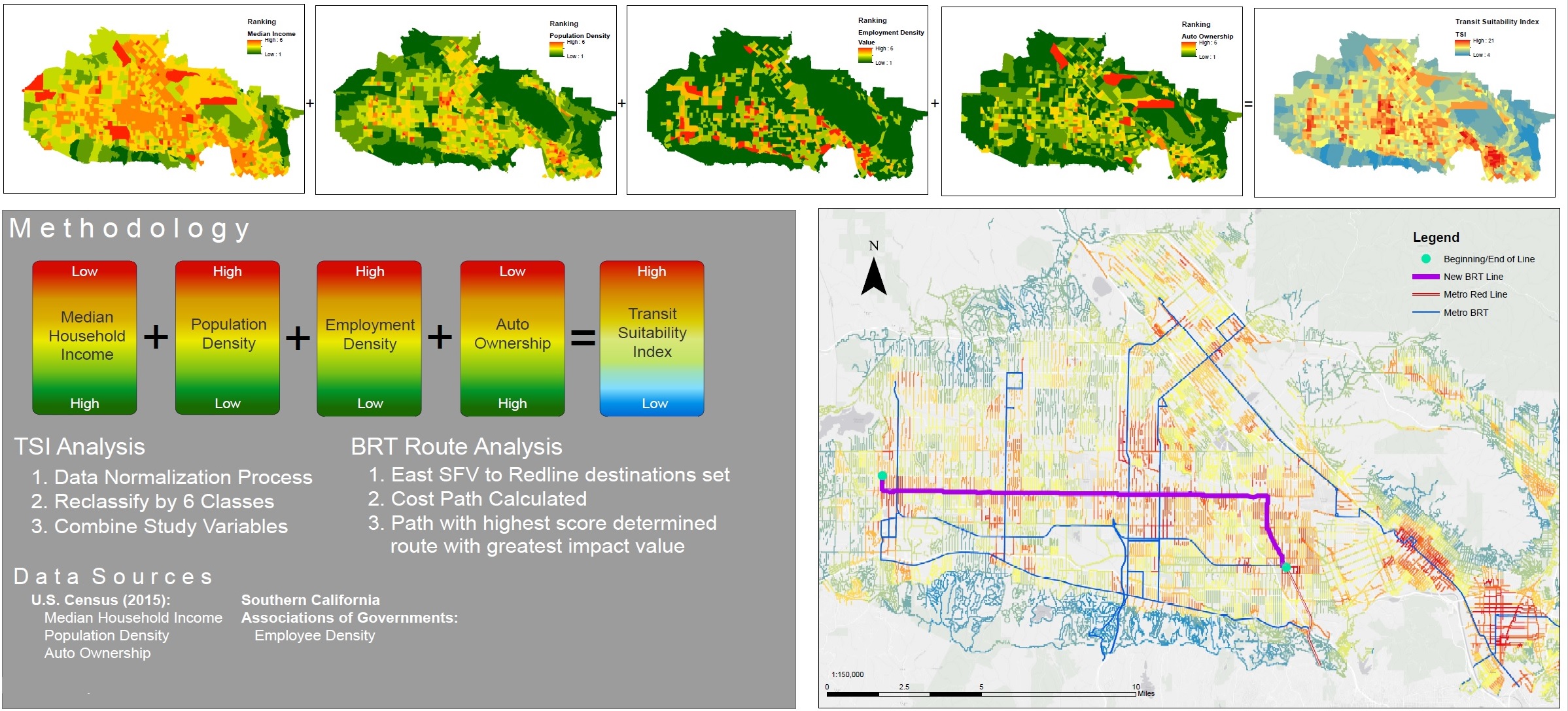 Transportation study of Southern California using GIS to map demographic information (Image courtesy of Professor Do Kim, 2015)
Cal Poly Pomona's hub for geospatial analysis, the GIS (Geographic Information System) Lab is supported by four colleges: Environmental Design; Engineering; Letters, Arts, and Social Sciences; and Science. This facility hosts interdisciplinary GIS instruction, research and projects in disciplines such as geography and anthropology, urban and regional planning, landscape architecture, biology, computer science, civil engineering and electrical and computer engineering.
The GIS lab contains an instructional lab with 30 workstations configured with ArcGIS 10.7 and ERDAS Imagine 2018. The GIS lab is dedicated to bridging traditional investigative methodologies with GIS/RS technologies for interdisciplinary research.
There are two URP computer labs in Building 3 (Room 3-1632 and Room 3-1640) available for students. Each computer lab is comprised of 24 student workstations and one teaching station. All stations are equipped with Dell PCs running Microsoft Windows 10 and supporting the following software:
- Microsoft Office Suite
- ESRI suite of GIS software (ArcGIS)
- Adobe Creative Suite
- Various statistical software including SPSS and STATA
Other software is available and the inventory of teaching software is updated regularly based on faculty requests. All stations are equipped with a large LED monitor. The computer lab also includes one projection screen, whiteboard, a digital projection system supporting data and video sources.
FAQ
Spatial Data Sources
- Berkeley Digital Library SunSITE
- University of Arkansas Libraries’ Guide to U.S. Geospatial and Attribute Data
Organizations
- URISA
“The Urban and Regional Information Systems Association (URISA) is a nonprofit association of professionals using [GIS] and other information technologies to solve challenges in state/provincial and local government agencies and departments.” - AAG
The American Association of Geographers - ASPRS
The American Society for Photogrammetry and Remote Sensing
Government Agencies
Undergrauate students can take the Interdisciplinary GIS Minor, an interdisciplinary program created for Cal Poly Pomona students whose majors include urban planning, landscape architecture, design, engineering, business, science, education, agriculture, social sciences, and humanities in an effort to create a GIS-literate campus.
The minor serves students who are interested in the application of GIS to their area of knowledge, or who seek to develop their skills in GIS-related areas. GIS technology offers new and powerful ways of combining data, mapping and spatial analysis to support research, management and policy-making. GIS users are trained in spatial modeling and know how to manipulate digital data, create databases, and streamline applications.
For information, contact:
Dr. Kelly Hu
GIS Minor Coordinator
khuh@cpp.edu | (909) 869-3591
No. Students can use the lab on a first-come, first-served basis without a reservation.
The Department of Urban and Regional Planning primarily uses the GIS Lab, as does the Department of Landscape Architecture. Instructors who teach a course in the lab can request keycard access for their students.